M.I.T. Classification system
MIT system of classification of soils was developed by Prof. G. Gilboy at Massachusettes Institute of Technology in USA. In this system, the soil is divided into four groups as follows:
(i)Gravel – particle size greater than 2 mm.
(ii) Sand – particle size between 0.06 mm to 2.0 mm.
(iii) Silt size – particle size between 0.002 mm to 0.06 mm.
(iv) Clay size – particle size smaller than 0.002 mm (2µ).

Boundaries between different types of soils correspond to limits when important changes occur in the properties. The particles less than 2µ size are generally colloidal fraction and behave as clay. The soils w particle size smaller than 2 μ are classified as clay size.
The naked eye can see the particle size of about 0.06 mm and larger. The soils with particles smaller than 0.06 mm but larger than 2μ are classified as silt-size. Important changes in the behaviour of soil occur if particle size is larger than 0.06 mm when it behaves as cohesion less soil. The boundary between gravel and sand is arbitrarily kept as 2 mm.
The soils in sand and silt-size-range are further subdivided into three categories: coarse (C), medium(M) and fine (F), as shown in the figure. It may be noted that MIT system uses only two integers 2 and 6, an easy to remember.
Textural Classification system
Texture means visual appearance of the surface of a material such as fabric or cloth. The visual appearance of a soil is called its texture. The texture depends upon the particle size, shape of particles and gradation of particles. The textural classification incorporates only the particle size, as it is difficult to incorporate the other two parameters.
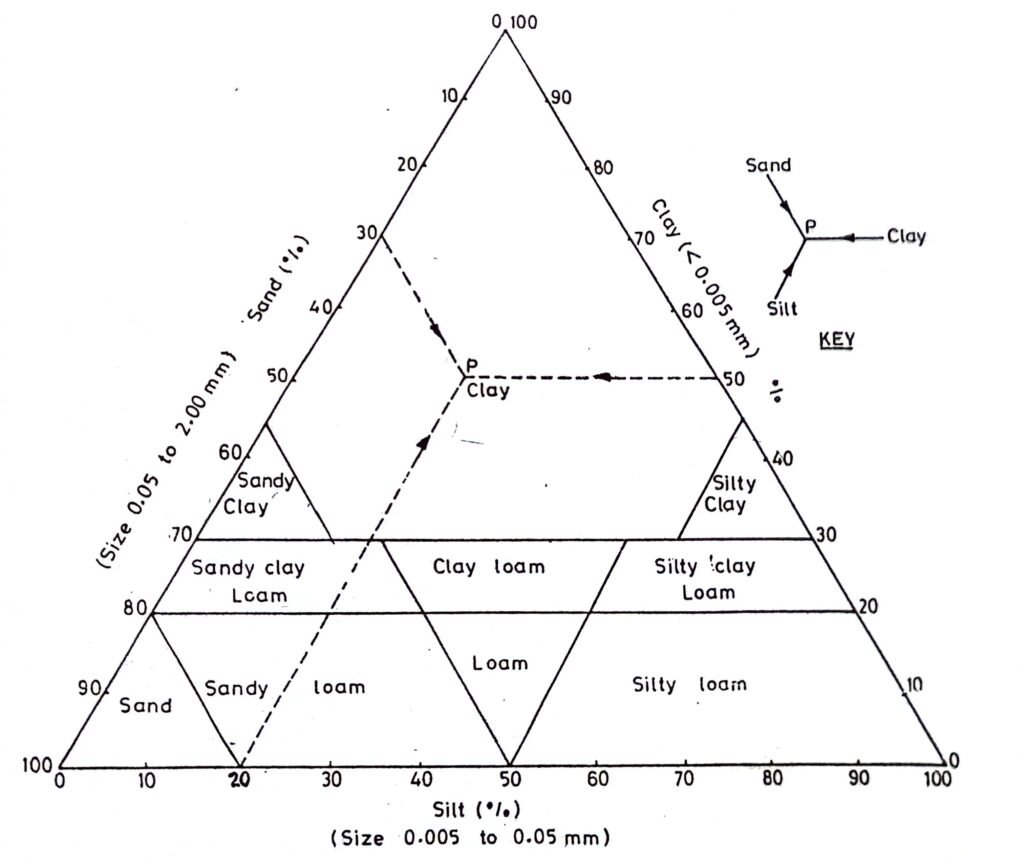
The triangular classification system suggested by U.S. Bureau of Public Roads in commonly known as the textural classification system. The term texture is used to express the percentage of the three constituents of soils, namely, sand, silt and clay as shown in the figure.

According to the textural classification system, the percentages of sand (size 0.05 to 2.0 mm), silt (size 0.005 to 0.05 mm) and clay (size less than 0.005 mm) are plotted along the three sides of an equilateral triangle. The equilateral triangle is divided into 10 zones, each zone indicates a type of soil. The soil can be classified by determining the zone in which it lies. A key is given that indicates the directions in which the lines are to be drawn to locate the point. For example if a soil contains 30% sand and 20% silt and 50% clay, it is shown by point (P) in the figure. The point falls in the zone labelled clay. Therefore, the soil is classified as clay.
The textural classification system is useful for classifying soils consisting of different constituents. system assumes that the soil does not contain particles larger than 2.0 mm size. However, if the soil contains a certain percentage of soil particles larger than 2.0 mm, a correction is required in which the sum of the percentages of sand, silt and clay is increased to 100%. For example, if a soil contains 20% particles of size lager than 2 mm size, the actual sum of the percentages of sand, silt and clay particles is 80%. Let these be respectively 12, 24 and 44%. The corrected percentages would be obtained by multiplying with a factor of 100/80. Therefore, the corrected percentages are 15, 30 and 55%. The textural classification of the soil would be done based on these corrected percentages.